We left Carlsbad near sunrise, which was around 7 am in the Mountain timezone of New Mexico, but 8 am directly South about an hour’s drive away in Texas, which is in Central timezone. A quirk of the artificial boundaries we like to place on space and time. Our destination was a Hipcamp we had reserved just outside of Big Bend National Park.
We retraced our steps from the previous day past White’s City and Guadalupe Mountains National Park, continuing through the seemingly endless, flat, Permian wastelands. Eventually it did end though, and the landscape started getting a little bumpier, a rolling hill there, a mesa there. Road signs informed us we were on the “Texas Mountain Trail”, although to our North-westerner eyes used to the Cascades and the Rockies it seemed more like the “Texas Hill Trail”.
Our first stop in Texas was in a little town called Van Horn. We pulled into a gas station for a bathroom break and snacks. As I was perusing the drink cooler, I overheard two men in conversation, both of course in the uniform of these parts, cowboy hat, Wranglers, and boots. The way they spoke was the most interesting part though, fluidly switching between English and Spanish, sometimes mid-sentence. Sometimes one would ask a question in English and the other would answer in Spanish. A testament to the unique blend of cultures here.
Our next stop was the town of Marfa, known as a quirky artists’ redoubt in the hardscrabble landscape of West Texas. Our main reason for stopping here was to visit the Chinatti museum, an old army base turned into a sprawling gallery and workspaces for resident artists. The main permanent exhibits are collections of huge sculptures by the artist Donald Judd. The first collection fills two massive “artillery sheds”. Each one is filled with boxes made from milled aluminum with the space inside broken up in different ways. The shed walls are all glass letting in sunlight that bounces off of the shiny metal at odd angles. Outside are similar sculptures. Huge boxes made of concrete instead of aluminum. After a stop at the post office to send some post cards, and then the grocery, we were on our way toward Big Bend.
As we continued South, the landscape started to get more mountainous, punctuated by mesas and canyons. Verdant from recent rains with dark clouds along the edges threatening more. At some point we lost cell reception and it didn’t come back.
We arrived at our Hipcamp called Coyote Crossing in the early evening. We turned off the main road just before the tiny town of Study Butte to a ramshackle collection of small buildings; a small house, a shed, a carport. We arrived just as the proprietor was getting home as well. He crawled out of his truck and greeted us, grocery bag and a 12 pack under his arm. A big man in a stained t-shirt, he proceeded to tell us how he’d arrived in these parts, canoeing down the Mississippi to the Gulf of Mexico, and then up the Rio Grande, getting a job as a river guide and never leaving. He also told us about the Spring Break hordes that had descended on the place a couple weeks prior and how he was quietly amused when their tents were sent airborne by the relentless desert wind. He sent us down into his 20 acre patch of dirt to find a spot to post up for the night. We selected a spot and made some dinner which we ate while watching a spectacular sunset.

Over night we learned why the place was called Coyote Crossing when we were awakened by howling coyotes a few feet from the camper. Despite that, we slept well and were up early to head into Big Bend National Park. After filling up on gas and coffee in Study Butte, we headed for the entrance. We were planning on staying in the park for the work week so our first order of business was to secure one on of the “primitive roadside camping” permits. These campsites are located along remote desert roads within the park and are generally only accessible by high-clearance, and often 4×4 vehicles. There are 54 of these sites altogether. Some can be reserved online while others are only available on a first-come-first-serve basis at the visitor’s center.
We were definitely a little nervous that we wouldn’t be able to get a site so we were relieved when we arrived at the Panther Junction Visitor’s Center and there wasn’t a long line of people clamoring for a site. We were able to talk to a ranger almost immediately on arrival. She was incredibly friendly and helpful walking us through the available sites, showing us pictures of them, and discussing the pros and cons of each. We settled on “Camp De Leon” off of Old Ore Road on the Eastern side of the park. With our site secured for the week we headed out for our first hike of the day.
The hike we chose for our first one in Big Gend was the “Burro Mesa Pouroff” trail. The hike started in typical scrublands, but quickly descended into a canyon. Even in the morning, the temperature was already quickly rising. The day would top out in the upper 90s. As we continued in the canyon, we heard the distinctive descending melody of Canyon Wren song and the vegetation got more lush. We came to a rock feature called a “window”, a full rock arch in a circular shape about 30 feet up from the canyon floor. A bit further, we found a beautiful pink flower growing out of cracks in the canyon wall called Cedar Sage. The smell was divine, like a sweet, minty sage. It would have been great to spice up our dinner later, but I resisted the urge to pluck a leaf as there wasn’t much of it.


The Pouroff itself came after a short vertical scramble which opened up to a wide chamber in the canyon. A Pouroff is to a waterfall what a wash is to a creek, that is, a waterfall without water. Looking over the edge, you can imagine water rushing through here and careening over, dropping a hundred or so feet. A narrow slit was created in the canyon wall where the blue sky and landscape beyond were visible.

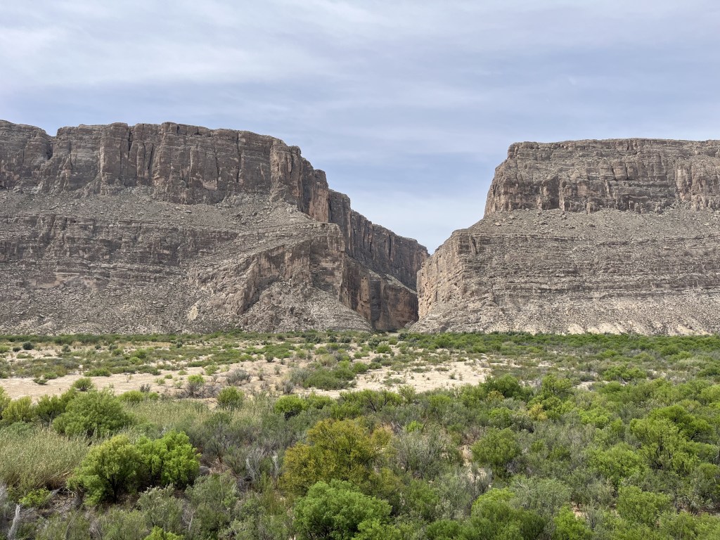
Next, we headed toward Santa Elena Canyon in the Southwestern corner of the park. We stopped at a viewpoint where we got our first look at the Rio Grande canyon and into Mexico. It isn’t the Grand Canyon, but it is still deep, wide, and impressive. Our original plan was to walk the trail up Santa Elena Canyon, but the parking lot was overflowing, which meant the short half mile trail was probably elbow to elbow. We decided it wasn’t worth the hassle of parking and combat hiking, so we turned around and headed back to a much less crowded picnic area we had seen by the river. We ate some lunch under a shade structure and then walked down for our first up close and personal contact with the mighty Rio Grande. It actually wasn’t that mighty. About ankle deep in the middle and perhaps 20 feet across. More like what we would call a creek back home. Still, it’s the lifeblood of this whole region and the lush riparian zone on it’s edges is a welcome respite from the scorching desert.


As afternoon approached, the temperatures started to climb into the upper 90s so we decided to spend the afternoon in the air conditioned comfort of the truck cab exploring some of the park’s backcountry roads . We drove up the Old Maverick Road from the canyon bottom back toward the park entrance. There were scary signs at the start warning that it was suitable for high clearance 4×4 vehicles only. It was rough in spots and a few wash crossing where some extra clearance was nice, but not too bad relatively speaking. We passed by a small adobe cabin called a Jacal that was slowly being swallowed by the desert. A nearby sign said it was built by a man named Luna who lived there until he was 108 years old! He raised a family there and farmed the area using water diverted from the river.


From there we drove up into the Chisos Mountains where we suspected it would also be cooler. The mountains are a 20 mile range totally contained within the park. With peaks rising to 7,500 feet or more, they offer a totally different climate, ecology, and scenery from the surrounding desert. The temperatures were a good 10 degrees cooler and the vegetation was much more varied with oak, pine, and juniper dominating. We stopped in at the Chisos Visitor’s Center where we filled our water bottles and indulged in ice cream sandwiches, a real treat on a hot day.
We drove back down out of the Chisos and over to the East Side of the park toward our campsite. The rangers were not kidding when they told us the road was rough. After about 30 minutes of bouncing down the road we arrived at our site. It was a wonderful site with no one around and a great view of the mountains to the North. It would be a great place to spend the work week.


Leave a comment